ELM CREEK — If you would have told me at the start of the season I would chase two tornado warned supercells in the span of one week I might have believed it.
If you told me it would have been the first week of July, I would have called you a liar.And yet that is exactly what happened, proving the 2024 storm season is not going out with a whimper.
On Monday, July 1, I pursued a tornado warned supercell from Oxford to Minden, feeling that I was lucky to get one more chase in before the summer heat made its full arrival.
However, to cap off the week, the chance for severe weather once again returned to central Nebraska.
In full disclosure, I knew storms were likely, but Saturday, July 6 just happened to be my partner Emaly’s birthday and I knew better than to plan a chase on her special day.
But when storms began initiating and strengthening in Dawson County, I couldn’t help but take a peek at the radar. What I saw was a severe thunderstorm producing hail over Gothenburg and Cozad, two communities that had seen widespread damage on June 29.
I am sure if those towns never see hail again, it will be too soon.
But what caught my attention was the pendant- like shape of precipitation on the southern edge of the thunderstorm complex. There was also some weak rotation co-located with the feature.
By this point in my storm chasing hobby, I have learned to trust my gut instincts and my mental alarm bells were ringing. But it’s your partner’s birthday, I hear all of the women saying, how could I think to leave?
I had a novel solution to my predicament: Emaly has never been on a chase with me, and with a severe thunderstorm practically in our backyard, I asked her to come with me.
We had a lighthearted moment while I was grabbing my camera gear. I saw Emaly wasn’t taking any jacket and I asked her if she would want to take hers. She told me she didn’t need it because she wasn’t going to get out of the car.
I was confused and asked her why. She simply said that it was going to be raining where we were going and didn’t want to get soaked.
I had to laugh to myself, if she thought I just pull up to a storm and park under some random rain shaft and call it a day – then this was the perfect time to show her what I really do.
We bundled into the car and headed west, the rain free base of the developing supercell was visible as we left our driveway and headed toward Elm Creek.
On the way I was telling Emaly that I look for the rain free base of a storm, as that is where the updraft will be located. On a supercell, this is the area you want to be near.
The storm was tracking to the southeast so I took us south and crossed Interstate 80 and the Platte River to put us downstream, so we could watch the storm come to us.
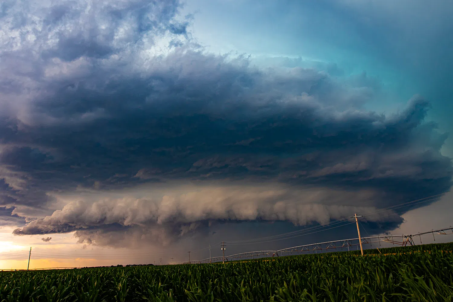
I found a spot off the roadway where we could stop and start observing. The time was just after 1 p.m. I told Emaly we were looking at a classic supercell.
A classic supercell exhibits low-level storm features that are visually identified by a well-defined wall cloud, a rain free base, a rear flank downdraft, and distinctly separate updraft and downdraft regions.
One thing I noted about this particular supercell was a blue hue that was often visible just above the rear flank gust front. This particularly shading would be maintained throughout its life and provided an excellent contrast in my photos.
I tossed Emaly one of my cameras and let her take some shots of the storm while I set up my video equipment. Photography has become one of my great passions and being able to share that with her in the moment meant a great deal to me.
We hadn’t been on scene for more than a few minutes when I double checked the radar and saw the red polygon appear on screen. The National Weather Service had issued a tornado warning for radar indicated rotation.
Emaly was able to see her first tornado warned supercell on her birthday, not too bad an experience to share with her, if I do say so.
From my vantage point I could see a small wall cloud developing, but I felt like the storm was a little early in its life to be ready to produce a tornado, if it ever was going to.
What was visually impressive was the clouds along the inflow tail were being drawn into the mesocyclone and they were distinctly being twisted up and around the column.
We held our position as long as we could, but eventually the rain from the forward flank was starting to close in. I quickly broke down everything, threw it in the car and bailed west.
We stopped south of Odessa, noting the growth of the inflow tail feeding into the storm. The hail core was going to pass perilously close to our home and Emaly maintains a garden she is rightfully proud of.
I asked her if she wanted to maintain the chase or if she wanted to be at home. We also have two cats that are not too fond of thunder.
Emaly decided one of us should be at home just in case, so I ran her up to the house and dropped her off. However, I was going to maintain the chase for the time being, but I had to get back into position.
With the rain of the forward flank falling all around me, I navigated around Kearney and then made my way past the Fort Kearny State Recreation area before heading south toward Minden.
The storm was moving slow enough that I felt it was worth the risk to get back in the inflow notch region. The structure of the storm had become even more visually impressive as I cleared the rain.
I crossed through Minden, not wishing to get trapped at a stop light if I had to get out of the way in a hurry. I eventually found a spot south of town to stop.
No sooner than I had done so, my phone began buzzing that a new tornado warning had been issued with Minden soon to be directly in the path.
The sight to the northwest was impressive, a classic supercell with a rear flank gust front bearing down on my position. All the while that same blue hue I had seen earlier was being maintained.
I jogged south a mile or two to give the storm some more distance because the gust front was coming on fast. With the worst of the storm passing over Minden, I double check the radar and didn’t like what I saw to the west.
A second round of storms had developed to the west of the current supercell and had concealed into a larger storm complex that was pushing toward my direction.
My parents, who live in northern Phelps County, had already endured one round of hail earlier and had to endure a second one that was passing over the area.
That same hail core seemed to be tracking toward Odessa and that thought caused my heart to sink, Emaly’s garden was likely to be pulverized.
In late June 2022, a storm I was chasing tracked over Odessa and produced a plethora of small hailstones that had shredded many plants in Emaly’s garden. She was beside herself at the time and I was begging for that not to happen again, and on her birthday of all days.
With the supercell passing over Minden, I could see there was a narrow gap between this storm and the oncoming complex that I could utilize to get home to be with Emaly, come what may.
I headed up to Highway 34 and started heading west, with the edge of the storm complex clearly visible on the horizon. I had a sense that I was racing a wrecking ball to get home.
However, as I turned north and looked back to the east, my wonder lust and photographer itch forced me to come to a stop, if only for the moment.
What I was looking at was the backside of the supercell’s anvil cloud that I had been chasing. It was filled with cloud streaks and puffy mammatus clouds, along with that same faint blue hue that had become that storm’s hallmark.
I paused to grab enough photos for a panoramic, fully aware I was ceding ground to the oncoming hail core. If I can give anyone advice, don’t get involved in storm photography, you’ll start to consider a picture worth a shattered windshield.
By the time I was south of Kearney, the heavier rain bands had arrived and I kept both hands glued to the wheel as I took the river road toward Odessa. The closer I got to my turn north, the clearer I could see a dark mass of precipitation that I knew was the hail core.
I had no time to look at the radar as I headed north and finally arrived at home, dashing inside through a blanket of rain, waiting for the worst to arrive.
But something truly strange happened.
After I made it inside and could pull up the radar, I saw that the northern end of the hail core that was on Odessa’s doorstep seemed to weaken significantly and the rest of the hail pushed almost due east.
I could only joke with Emaly that Mother Nature’s birthday gift to her was choosing not to destroy her garden.
As it turned out, the storm complex I had raced home would go on to produce a brief tornado in the Minden area. I wasn’t too upset at missing this tornado, even though I had been in the area.
The unexpected chase had yielded some of my favorite photographs of the year, but at the end of the day, it was Emaly’s birthday and I wanted to be home with her.
Emaly quipped to me later that she enjoyed seeing her first tornado warned supercell and that she wouldn’t mind going out again, but under no circumstances is she driving five hours one way for a potential glimpse at a storm.
Backyard chases only for her – noted.
